High Dams, Humongous Fungus, and Kam Wah Chung
The Blue Mountains as defined by the World Wildlife Fund are complex in biological communities, with a variety of habitats based on elevation. Communities include sagebrush, pinyon-juniper, ponderosa pine, Douglas-fir, western larch, spruce, lodgepole pine, chaparral, mountain meadows and grasslands which extend from western-central Idaho to the Cascade Mountains near Prineville, Oregon. Geologically, the Blue Mountains are believed to be an island arc that originated in the eastern equatorial Pacific. During the Mesozoic Era, this island arc moved northeastward and was attached to North America. The point of attachment to the Idaho Batholith was in the Hells Canyon area (Vallier and Brooks 1986).
The conifer forests of the Blue Mountains are parasitized by the Armillaria ostoyae fungus, which causes a root disease, killing some species. In the Malheur National Forest, the network of fungal mycelia has grown very large. Studies of the fungi in the forest has revealed that there are five areas where all the Armillaria mycelia are genetically identical. These areas are called genets. The humongous fungus, the world’s largest living organism, is found in the Grouse Knob area, covers 2,385 acres in area, and weighs from 8,000 to 35,000 tons. The organism is a network of fungal mycelia and its age is from 1,900 to 8,600 years (Schmitt and Tatum 2008).
Hells Canyon was the site of one of the epic battles over dam building during the 1950s and 1960s. Federal agencies attempting to continue the New Deal legacy of federal dam building proposed building a “high dam” in Hells Canyon near the confluence of the Salmon and Snake Rivers. Other public power agencies proposed dams also. The High Mountain Sheep Dam license was overturned by the Supreme Court in 1964, based on the need to address fish, wildlife, and recreation needs and other public interest considerations. However, Idaho Power had applied for, and received, a license to build a smaller three-dam complex in Hells Canyon in 1947. The defeat of the High Mountain Sheep proposal allowed Idaho Power to complete its three-dam complex. One reason the Idaho Power proposal ultimately prevailed was because of political battles over the role of public and private power and federal planning and regulation in general. For example, there was fear that new federal dams would allow Bonneville Power Administration to become the TVA of the Pacific Northwest, and that private irrigation interests would be harmed (Brooks 2006). The Hells Canyon National Recreation Area and Hells Canyon Wilderness areas, described below, are also legacies of the Hells Canyon Dam battles of the 1960s.
There is one National Historic Landmark in the Blue Mountains forests. Kam Wah Chung State Heritage Site, Oregon (N44˚25’ W118˚57’), is in the town of John Day on Canton Street. It commemorates Chinese immigration to Oregon, which took place to serve the gold mining communities in the area. Kam Wah Chung & Company was operated by two Chinese immigrants as an apothecary and general store from 1888 to the 1940s, and contains the largest collection of traditional Chinese medicines in the U.S. The store also served as a religious and cultural community center for more than 50 years.
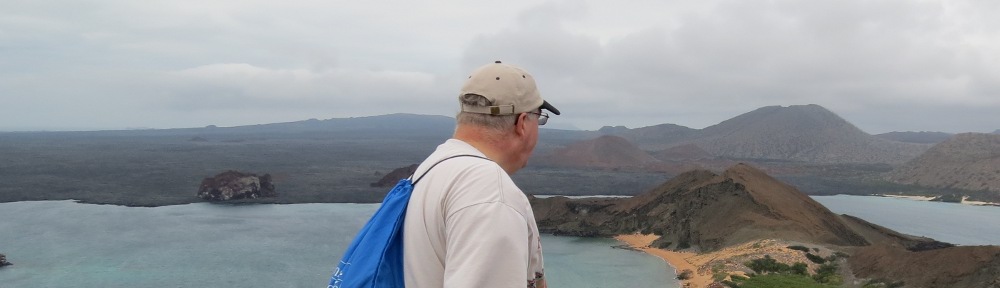
There is one National Natural Landmark in the Blue Mountains forests. Sheep Rock, Payette National Forest, Idaho (N45˚11’ W116˚40’), is on Forest Road 106 about 42 miles from US Route 95 at Council. A one-half mile trail provides a scenic overlook of Hells Canyon. The landmark provides a view of horizontally layered lavas formed by successive flows on the Columbia River plateau which took place during the Miocene Epoch (Gray 2012). Two lava flows are separated by a visible uncomformity.
The National Forest System in the Blue Mountains forests consists of the Hells Canyon National Recreation Area and adjoining national forests in Idaho and Oregon. Three other national forests, the Umatilla, Malheur, and Ochoco, follow the ridges from Hells Canyon westward to the Cascade Mountains. The description begins with the Idaho national forests that border Hells Canyon and then moves westward. The Blue Mountains portion of the Boise NF, Idaho, in the Blue Mountains consists of the Sage Hen Management Area (N44˚20’ W116˚11’) atop West Mountain on the border with the Idaho batholith. Nez Perce NF, Idaho, is 2.2 million acres. The northeastern approaches to Hells Canyon are through the Nez Perce NF. Forest Route 493 from White Bird provides access to Pittsburg Saddle (N45˚40’ W116˚24’), which continues to Pittsburg Landing on the Snake River. Forest Route 517 provides access to Seven Devils (N45˚21’ W116˚30’) and Heavens Gate overlooks on the east side of Hells Canyon Wilderness. Seven Devils is part of the Wallowa terrane, a former island arc off the western coast of North America which was accreted to the continent in the Late Jurassic to early Cretaceous time period (Gray 2012). Forest Route 241 provides access to Sawpit Saddle (N45˚32’ W116˚25’), another Hells Canyon viewpoint. The Rapid and West Fork Rapid Rivers in the forest are part of the national wild and scenic river system. The relatively low elevation makes the Rapid River accessible year-round. Trails follow the river and its west fork and connect to Seven Devils in the Hells Canyon National Recreation Area to the west (Chisholm 2014).
Payette NF, Idaho, is 2.3 million acres in both the Salmon River Mountains to the east of US 95/State Route 55 and the Seven Devils Range to the west of US 95. In the Blue Mountains, the Hells Canyon/Seven Devils Scenic Area is adjacent to Hells Canyon NRA and Hells Canyon Wilderness. Within this area is Sheep Rock NNL (see separate description). These are steep glaciated mountains and canyons, dominated by volcanic rocks. Vegetation is grassland and ponderosa pine in higher elevations. There are 40 miles of trails. The Snake River Road follows the shore of Hells Canyon Reservoir through the Payette NF from Oxbow (N44˚58’ W116˚51’) north to Hells Canyon Dam (N45˚15’ W116˚42’).
To the south of Hells Canyon, the forest lands are grasslands and forests on Columbia River basalts. There are five RNAs, Bear Creek, Rocky Comfort Flat, Cuddy Mountain, Emery Creek, and Lost Basin Grasslands. Bear Creek RNA (N45-7 W116-33) is located on a ridge between Bear Creek and Wesley Creek and contains grand fir forests in the Blue Mountains. Rocky Comfort Flat RNA (N44-58 W116-43) is a plateau-like peninsula surrounded by the canyons of Bear Creek and the Crooked River, forested with mountain mahogany, Douglas-fir and sagebrush.
The Weiser River drainage forms a semicrircle around Council, Cambridge, and Indian Valley, which are on US 95. Council Mountain RNA (N44-42 W116-16) is located between Council and Donnelly and is the highest summit in the West Mountains. Vegetation is mountain big sagebrush with small forest islands. Other features of this area are Lost Valley Reservoir and Rush Creek Falls.
The Rapid River drainage is west of US 95 in the Blue Mountains, providing important habitat for salmon, steelhead, and bull trout. The upper end of the Rapid Wild River is in the Payette NF.
Hells Canyon National Recreation Area, Idaho-Oregon is 652,000 acres in both the Palouse Prairie ecoregion and the Blue Mountains forests ecoregion. Hells Canyon of the Snake River is the deepest river gorge in North America, with an 8,000 foot elevation change.
In the Blue Mountains of Oregon, Hells Canyon Scenic Byway (Forest Highway 39) extends from State Route 86 at North Pine Creek (N44˚55’ W116˚57’) to Hells Canyon Overlook (N45˚7’ W116˚51’) and on to Lick Creek Campground (N45˚10’ W117˚2’). The byway continues outside of the NRA in the Wallowa NF and along State Routes 82 and 86. The byway passes the Imnaha River, which is a wild and scenic river for 60 miles in the national recreation area from the Eagle Cap Wilderness (N45˚6’ W117˚4’) downstream to the Snake River (N45˚49’ W116˚46’). Its elevation drop is more than 7,000 feet. The Imnaha River Road (Forest Road 3960) follows the Imnaha River upstream to Indian Crossing Campground (N45˚7’ W117˚1’). Duck Lake RNA N45˚6’ W117˚0’) is 500 acres with a low elevation pond and a vernal pond with a sphagnum bog amid old-growth ponderosa pine and Douglas-fir communities. Hat Point Road (Forest Road 4240) climbs from the Imnaha River (N45˚33’ W116˚49’) up the cliffs of Grizzly Ridge to Saddle Creek Overlook and on to Hat Point (N45˚26’ W116˚40’) for one of the most spectacular views. It is a one-lane unpaved road.
On the Idaho side, Pittsburg Landing Road (County Road 493) extends from White Bird on US Route 95 southwest to the Snake River, passing through the Nez Perce National Forest and entering the National Recreation Area at Pittsburg Saddle (N45˚40’ W116˚24’). Pittsburg Landing (N45˚38’ W116˚29’) provides river access. The Snake River NRT leads upstream to Kirkwood Historic Ranch (N45˚34’ W116˚30’) and into the Hells Canyon Wilderness (see). From Riggins on US Route 95, Forest Highway 241 and Forest Road 2060 wind to the Sawpit Saddle Viewpoint (N45˚32’ W116˚30’) and nearby Low Saddle Viewpoint. Heavens Gate Overlook (N45˚22’ W116˚30’) is accessible from Forest Road 517 from Riggins through the Nez Perce NF. The Snake River Road follows the shore of Hells Canyon Reservoir through the Payette NF from Oxbow (N44˚58’ W116˚51’) north to Hells Canyon Dam (N45˚15’ W116˚42’). There is a visitor center at Hells Canyon Creek below the dam on the Oregon side.
Wallowa NF, Oregon, is 995,000 acres, administered together with the Whitman NF. Much of the eastern portion is now part of the Hells Canyon NRA (see separate description). South of Joseph at Wallowa Lake, the Wallowa Lake Tramway is the steepest vertical lift of a gondola in North America, with a 4,000-foot elevation change. The southeastern portion of the forest is mostly the watershed of Big Sheep Creek, which is eligible for the national wild and scenic river system from the Eagle Cap Wilderness boundary (N45˚11’ W117˚6’) to the Imnaha River confluence (N45˚33’ W116˚50’). Lostine River is designated as a wild and scenic river for 16 miles from its headwaters (N45˚12’ W117˚21’) downstream to the Wallowa National Forest boundary (N45˚24’ W117˚26’).
In the section of the forest north of Enterprise, the Joseph Canyon Viewpoint (N45˚50’ W117˚16’), a site of the Nez Perce National Historical Park, is located on State Route 3 south of the Washington State Line. The deep canyon to the east of Route 3 is Swamp Creek, which contains outstanding scenery from its confluence with Joseph Creek (N45˚49’ W117˚4’) upstream to the forest boundary (N45˚36’ W117˚13’). Joseph Creek is a wild and scenic river for nine miles from Joseph Creek Ranch (N45˚48’ W117˚11’) downstream to the Wallowa NF boundary (N45˚52’ W117˚15’).
Whitman NF, Oregon, is 1.3 million acres, administered together with the Wallowa NF. The North Fork John Day Wilderness, Baldy Creek Unit, is within the forest and the North Fork John Day unit is shared with the Umatilla NF. The Oregon Trail crosses the forest for six miles along I-84. The Oregon Trail Interpretive Park (N45˚24’ W118˚19’) is located at one of the best preserved segments of the trail.
In the Grande Ronde Watershed upstream from La Grande, Five Points Creek (N45˚24’ W118˚13’), a tributary to the Grande Ronde River near La Grande, is considered eligible for the national wild and scenic rivers system. The stream flows through a remote and primitive canyon. The Grande Ronde River to the south of LaGrande (N45˚13’ W118˚’) is also considered a scenic area in the northern Elkhorn Mountains.
Gerald S. Strickler RNA (N45˚19’ W118˚33’), is 195 acres south of Forest Highway 21 and north of the Starkey Experimental Forest. It was established for research on a bunchgrass/oatgrass community with grand fir-Douglas-fir-ponderosa pine forests.
In the Elkhorn area of the forest west of Baker, the Elkhorn Scenic Byway (Forest Highway 73) completes a big loop from west of North Powder (N44˚59’ W118˚5’) to Sumpter at State Route 7 (N44˚43’ W118˚10’). Along this route, Anthony Lake is at the foot of Gunsight Peak (N44˚57’ W118˚14’), which has a prominent notch. State Route 7 through the forest is the Journey through Time Scenic Byway. Charles Grier Johnson, Jr., RNA (N44˚55’ W118˚20’) is on Forest Highway 73 on the North Fork John Day River and represents aspen and tufted hairgrass communities in a meadow along the river. East of the North Fork John Day Wilderness, the North Powder River (N44˚55’ W118˚10’) is a unit of the national wild and scenic river system for six miles from its headwaters to the forest boundary. Dutch Flat Creek (N44˚57’ W118˚10’), a tributary to the North Powder River, is eligible for the national wild and scenic river system. The stream exhibits outstanding examples of glacial geology, including a terminal moraine at the forest boundary. Also exhibiting outstanding scenery are Rock Creek (N44˚52’ W118˚7’) and Killamacue Creek (N44˚53’ W118˚8’), both of which are visible from the Elkhorn Crest NRT.
In the Wallowa Mountains portion of the forest, Point Prominence RNA (N45˚23’ W117˚43’) is 360 acres with a subalpine fir-big huckleberry community. To the south, Indian Creek RNA (N45˚19’ W117˚43’) contains a mountain hemlock community. Eagle Creek is a unit of the national wild and scenic river system from Eagle Lake (N45˚8’ W117˚20’) to the forest boundary (N44˚52’ W117˚14’). The river is noted for waterfalls and glacial features. East Eagle Creek is considered eligible for the national wild and scenic river system from its headwaters near Horton Pass (N45˚10’ W117˚19’) to its confluence with Eagle Creek (N44˚59’ W117˚22’). Granite Cliff towers 4,000 feet over the East Eagle Trailhead (N45˚4’ W117˚18’). North Fork Catherine Creek was found to have outstandingly remarkable values from its headwaters (N45˚13’ W117˚35’) downstream to the forest boundary (N45˚7’ W117˚39’). South of the Eagle Cap Wilderness, Clear Creek Ridge proposed RNA (N45˚4’ W117˚10’) is 637 acres and includes green fescue communities. Lake Fork RNA (N45˚1’ W116˚56’) is 200 acres with bluebunch wheatgrass, Wyeth’s buckwheat, and Cusick’s camas seepage plant communities. It is adjacent to Hells Canyon NRA. In the southwest portion of the Whitman NF south of Unity is the Monument Rock Wilderness (N44˚20’ W118˚19’), described separately.
Umatilla NF, Oregon-Washington, is 1.4 million acres. The three wilderness areas, Wenaha-Tucannon, North Fork Umatilla, and North Fork John Day, are described separately. The northern part of the forest is south of Pomeroy, Washington. This portion of the forest contains three botanical areas and one RNA. Charley Creek Botanical Area, Washington (N46˚15’ W117˚29’) provides habitat for the Wenaha currant. Karl Urban Botanical Area, Washington (N46˚12’ W117˚38’) surrounds Sheep Creek Falls and is 500 acres, with habitat for rare ferns, mosses, lichens. Forest Road 4712 along the Tucannon River provides access. Sheep Creek in the botanical area is eligible for the national wild and scenic river system. Sourdough Proposed Botanical Area, Washington (N46˚15’ W117˚22’) is 1,500 acres in the northeastern portion of the forest in the transition area between forest and the Palouse prairie. Pataha Bunchgrass RNA, Washington (N46˚17’ W117˚30’) is a bunchgrass and bluegrass community on Forest Highway 42 (Iron Springs Road) at the northern edge of the forest. The Tucannon River from its origin (N46˚7’ W117˚30’) to the forest boundary (N46˚18’ W117˚39’) is considered eligible for the national wild and scenic river system. Bear Creek (N46˚9’ W117˚34’), a tributary of the Tucannon River, is also considered eligible and is within a roadless area south of Forest Highway 40.
South of the Wenaha-Tucannon Wilderness, there are additional special areas. The Kendall Skyline Road (Forest Highways 64 and 46; not all passable by passenger car) extends from Mountain Top, Washington (N46˚14’ W117˚46’) south to Langdon Lake, Oregon (N45˚47’ W118˚5’) at the junction with State Route 204, passing the western side of Wenaha-Tucannon Wilderness (see). West of the Skyline Road, the Mill Creek Municipal Watershed (N46˚0’ W118˚0’) is a watershed protection area for the City of Walla Walla. Mill Creek Watershed proposed RNA, Oregon-Washington (N45˚59’ W118˚0’), is 7,500 acres established to recognize disjunct red alder communities from the Cascade Mountains. It is along Low, Broken, and Paradise Creeks.
From Troy (N45˚57’ W117˚27’), the Wenaha River Trail leads upstream to the Wehaha-Tucannon Wilderness boundary (N45˚59’ W117˚33’). The Wenaha River is part of the national wild and scenic river system. Elk Flats Meadow Botanical Area, Oregon (N45˚55’ W117˚46’) is on Forest Highway 62 west of Troy. To the south, the Grande Ronde Scenic Area, Oregon (N45˚51’ W117˚46’) includes 9,150 acres of canyons overlooking the Grande Ronde Wild and Scenic River, which is on the forest boundary from mile 62 (N45˚52’ W117˚38’) upstream to mile 80 (N45˚45’ W117˚47’). Big Sink Geological Area, Oregon (N45˚47’ W117˚56’) is on Forest Highway 63 east of Tollgate. The three-mile-wide feature appears to be an ancient landslide. Target Meadows Historic Area, Oregon (N45˚48’ W118˚5’) is on Forest Road 50 north of Tollgate and was used for artillery practice. Lookingglass Creek, a tributary of the Grande Ronde River, is considered eligible for the national wild and scenic river system from State Route 204 (N45˚47’ W118˚5’) downstream to the forest boundary (N45˚45’ W117˚56’).
To the south of the North Fork Umatilla Wilderness are three botanical areas. Farr Meadows Proposed Botanical Area (N45˚42’ W118˚2’) is on State Route 204 at Andies Prairie. Ruckel Junction Botanical Area (N45˚39’ W118˚8’) is on Forest Highway 31 north of Forest Highway 32 junction and contains habitat for Sabine’s lupine. Shimmiehorn Canyon Botanical Area (N45˚39’ W118˚12’) is noted for its ferns. It is west of Forest Highway 31 and accessible by foot.
Along I-84 at Exit 243, the Whitman Route Interpretive Site (N45˚28’ W118˚15’) is off of Forest Highway 31 (Mount Emily Road) and Forest Road 3109. From the view of Meacham Creek Canyon the route of the Whitman Missionaries in 1836 can be traced.
In the North Fork John Day area, Olive Lake-Freemont Powerhouse Historical Area is the remnant of a power development constructed in 1908 to provide power to the town of Granite and to support the Red Boy Gold Mine. A hydroelectric flume connected Olive Lake (N44˚47’ W118˚36’) with Fremont Powerhouse. Desolation Creek, a tributary to the North Fork John Day River, is eligible for the national wild and scenic river system from the confluence of the North and South Fork Desolation Creek (N44˚49’ W118˚56’) downstream to its confluence with the North Fork John Day River (N45˚0’ W118˚56’). The North and South Forks of Desolation Creek are also considered eligible streams. Forest Highway 10 parallels the creek for several miles. Along the North Fork is Desolation Meadows, a unique botanical area. The South Fork drains the 35,000-acre Vinegar Hill-Indian Rock Scenic Area (N44˚46’ W118˚40’), which provides spectacular views of the North Fork John Day River gorge to the north and the Strawberry Mountains to the south. In the southern edge of the forest is Greenhorn Historical Area (N44˚43’ W118˚30’), which is a ghost town associated with gold mines. Vinegar Hill proposed RNA (N44˚43’ W118˚33’) is a subalpine big sagebrush community on the Greenhorn mountain crest.
In the area of the forest north of Camas Creek (State Route 244), Birch Creek Cove proposed RNA is a grand fir old growth forest with a filled in pond. It is located between Forest Road 20 and the West Fork Birch Creek. Yellow Jacket Road (Forest Road 5415) leads south from Pilot Rock to the area. In the unit of the forest south of Heppner, Kahler Butte proposed RNA (N44˚55’ W119˚41’) is 84 acres of a mima mound landscape type. There are upper and lower benches with scabland sagebrush and scrublands surrounded by a forest of juniper and ponderosa pine. The site is off of State Route 207. The Blue Mountain Scenic Byway is Forest Highway 53 between Heppner and Ukiah (N45˚12’ W119˚20’ to N45˚10’ W119˚4’). The byway continues east of Ukiah as Forest Highway 52 (N45˚5’ W118˚55’) and intersects the Elkhorn Scenic Byway (Forest Highway 73) (N44˚55’ W118˚24’) along the upper North Fork John Day River.