Muskwa-Slave Lake forests, Part 2
This ecoregion is in northern Alberta, British Columbia, and Northwest Territories and includes the area to the south of Great Slave Lake. Sites in Alberta and British Columbia were described in a previous post. Vegetation consists of closed stands of quaking aspen, spruce, and balsam fir with lesser amounts of balsam poplar and black spruce. Sporadic permafrost, wetlands, and bogs cover up to one-half of the land. The ecoregion supports large-scale mammal migrations.
The Great Slave Lake, the deepest lake in North America at 600 m and the 10th largest in the world (500 km by 225 km), is named after a First Nations people, known as the Slave or Dene. The largest river flowing into the lake is the Slave River, from the south, and the lake drains from its west side by the Mackenzie River, an Arctic Ocean tributary.
World Heritage Sites in Muskwa-Slave Lake Forests:
Wood Buffalo National Park, the largest national park in Canada at 44.8 million ha, is in Alberta and Northwest Territories. Established to protect the last remaining herds of the wood bison subspecies, it was later found to be the only remaining nesting ground of the whooping crane. Vegetation is the largest undisturbed grass and sedge meadows in North America, with a patterned landscape of muskeg, shallow lakes, coniferous and mixed forest. The park is also a Dark Sky Preserve.
Wood bison calving grounds are in the Peace-Athabasca Delta (N58ᵒ50’ W112ᵒ0’) and in the Darrow Creek meadows area (N59ᵒ25’ W111ᵒ37’) of the park, both in the eastern areas of the park. Wood bison are North America’s largest land mammal. In this park, the predator-prey relationship between wolves and wood bison has continued, unbroken, over time. The whooping crane nesting grounds (N60ᵒ15’ W113ᵒ15’), a Key Biodiversity Area and Important Bird Area, are in the northeastern portion of the park. Extensive salt plains (N59ᵒ50’ W112ᵒ10’) are accessible from Route 5. Wood Buffalo National Park contains the finest example of gypsum karst in North America (N60ᵒ20’ W114ᵒ15’). Other park sites are the Birch River (N58ᵒ15’ W113ᵒ25’), Garden River (N58ᵒ43’ W113ᵒ48’), Peace Point (N59ᵒ8’ W112ᵒ27’), Buffalo Lake (N60ᵒ15’ W115ᵒ20’) and an area of upland tundra (N59ᵒ35’ W114ᵒ50’).
Ramsar Sites in Muskwa-Slave Lake Forests
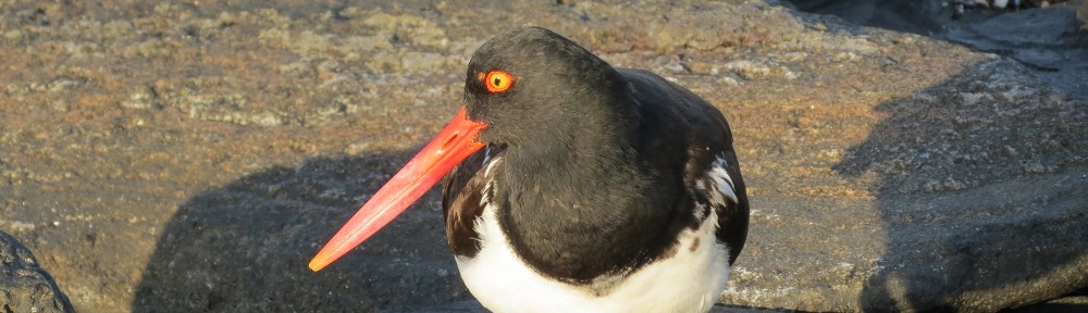
Peace-Athabasca Delta (N58˚50’ W112˚0’), within Wood Buffalo National Park, is the largest freshwater delta in the world’s boreal forests, spanning 3 river deltas (Athabasca, Birch, and Peace) and four large freshwater lakes. An Important Bird Area and Key Biodiversity Area, the delta is one of the most important nesting, resting and feeding areas for waterfowl in North America, and is also a wood bison calving ground. Vegetation is open grass and sedge meadows. The delta provides thousands of miles of shoreline for nesting waterfowl from all four flyways. Breeding species include Canada goose, mallard, gadwall, American wigeon, northern pintail, green-winged teal, blue-winged teal, northern shoveler, canvasback, whooping crane, bald eagle, and osprey.
Whooping Crane Summer Range (N60ᵒ15’ W113ᵒ15’), is within Wood Buffalo National Park and is the only remaining nesting area for whooping crane. The thousands of marshes, shallow ponds, streams, lakes, and bogs within this area provide habitat at the northern limit of boreal forest. It is an important Bird Area and Key Biodiversity Area.
National Sites
Edehzhie Dehcho Protected Area and National Wildlife Area (N62o W118o) is 1,425,000 ha, including the Horn Plateau west of Great Slave Lake and Mills Lake area along the Mackenzie River. The expansive area of boreal forests and wetlands is jointly managed by the Dehcho First Nations and the Canadian Wildlife Service, part of Environment and Climate Change Canada. Wildlife includes caribou, moose, and wolves. Mills Lake Important Bird Area (N61o27’ W118o17’) is a widening of the Mackenzie River near the confluence with the Horn River. It is an important September-October migration stop for greater white-fronted geese, tundra swan, snow geese, Canada geese, ducks, and coots.
Fort Resolution National Historic Site (N61o10’ W113o45’) is the site of the oldest trading post in the Northwest Territories, dating to 1819. The site is on a peninsula on the Great Slave Lake near the present-day town of the same name. No remains are present.
Hay River Missions National Historic Site (N60o52’ W115o44’) is on the right bank (facing downriver) of the Hay River at its confluence with Great Slave Lake. The site is the half-way point of a 2,500-mile waterway between Athabasca Landing north of Edmonton and the Arctic Ocean. In 1868, Hudson’s Bay Company opened a fur trading post and Catholic mission at the site. Between 1893 and 1937, an Indian residential school was on the site. In 1909, St. Peter’s Anglican Church was constructed at one end of the settlement, and in 1940, St. Anne’s Roman Catholic Church was constructed at the other end. The national historic site consists of the two churches, remains of a rectory, associated cemeteries, and spirit houses. Together, these represent a cultural landscape that commemorates decades of interaction between K’atl’odeechee First Nation and settler populations.
Territorial and other sites
Beaver Lake Important Bird Area (N61o7’ W117o12’) is a wide part of the Mackenzie River at the west end of Great Slave Lake. It is important for tundra swans.
South Shore Great Slave Lake Important Bird Area extends along the shoreline from the Slave River Delta (N61o18’ W113o38’) to Taltson River (N61o26’ W112o48’). It is an important spring and fall migration stop for tundra swans, snow geese, ducks, and Canada geese.
Parks on Route 1 (Mackenzie Highway)
60th Parallel Territorial Park (N60o0’ W116o59’) is at the Alberta Border on Route 1 and serves as a visitor center for traffic entering the Northwest Territories. There are overlooks of the Hay River.
Twin Falls Territorial Park (N60o31’ W116o3’) includes a trail to both Alexander and Louise Falls, on Hay River south of Enterprise at km 72 on Route 1.
McNallie Creek Territorial Park (N60o47’ W116o35’) is north of Enterprise at km 120 on Route 1 and includes a 17-m waterfall.
Lady Evelyn Falls Territorial Park (N60o58’ W117o20’) is on Route 1 at km 167. The falls are on the Kakisa River south of Route 1.
Kakisa River Territorial Park (N61o0’ W117o20’) is on Route 1, km 169, and includes a trail to Lady Evelyn Falls.
Sambaa Deh Falls Territorial Park (N61o9’ W119o51’) is on Route 1, km 325, at the Trout River. The park includes two waterfalls and is noted for coral fossils.
Park on Route 2 (Great Slave Route)
Hay River Territorial Park (N60o52’ W113o44’) is at the mouth of Hay River off Route 2, km 46, at Vale Island.
Parks on Route 3 (Yellowknife Highway)
Dory Point Territorial Park (N61o15’ W117o29’) is on Route 3, km 21, at the Mackenzie River.
Fort Providence Territorial Park (N61o20’ W117o37’) is at Fort Providence on the north side of the McKenzie River, Route 3 km 33.
Mackenzie Bison Sanctuary is bordered by Great Slave Lake on the east and Route 3 (Frontier Highway) on the west for 50 miles; it begins on the north side of Mackenzie River bridge; km 26 is the bison sanctuary boundary. The Mackenzie population of wood bison descended from a population of 18 individuals released north of Fort Providence in 1963. Numbers currently fluctuate between 500 and 2,000. In recent years the population has suffered from anthrax outbreaks. In addition, lakes are expanding in area due to climate change. The resulting landscape flooding is reducing their habitat (Korosi et al., 2017).
Parks on Route 5 (Fort Smith Highway)
Little Buffalo River Falls Territorial Park (N60o2’ W112o42’) is west of Fort Smith at km 215 on Route 5.
Queen Elizabeth Territorial Park (N60o1’ W111o55’) is in Fort Smith at km 261 on Route 5, and includes views of the Slave River and white pelican colonies.
Fort Smith Mission Territorial Park (N60o0’ W111o53’) is in the center of town at 25 Mercredi Avenue. It was briefly the capital of the Northwest Territories and includes the remaining buildings and a grotto from Oblate Catholic Mission.
Park on Route 6 (Fort Resolution Highway)
Little Buffalo River Crossing Territorial Park (N61o0’ W113o46’) is at km 67 on Route 6 south of Fort Resolution.
Reference:
Korisi, Jennifer B. et al. 2017. Broad-scale lake expansion and flooding inundates essential wood bison habitat. Nature Communications 8:14510 (DOI: 10.1038/ncomms14510).